
Elaboration of Risk Maps associated with ARPSIs
The work consists of the preparation of risk maps associated with the Areas of Potential Significant Flood Risk (ARPSI) of the Duero River Basin District
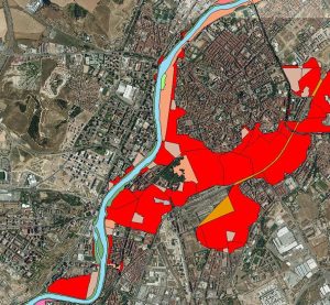
Description of the Works:
The project consists of the elaboration of risk maps associated with the Areas of Potential Significant Flood Risk (ARPSI) of the Duero River Basin Demarcation.
The following work will be performed:
- Obtaining the indicative number of potentially affected habitants in each ARPSI.
- Reclassification of land uses based on a geographic information layer that allows this operation and obtaining the affected land uses for each ARPSI.
Customer: Confederación Hidrográfica del Duero
Allocation Date: 2013
![]()
- Assessment of the affected Integrated Pollution Prevention and Control (IPPC) and W.P.P. facilities according to the available geographic information layers for each ARPSI.
- Avoidance of the protected areas for the collection of water intended for human consumption, recreational waters and areas for the protection of habitats or species that may be affected according to the available geographic information layers, for each ARPSI.
- Assessment of road infrastructure based on the road and rail network contained in the official cartography, with the estimation of average widths by type of road, for each ARPSI.
- Preparation of estimations and evaluation tables for each ARPSI.